


Bethel-Roberts VFD, Escambia County, Alabama
About
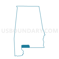
Outline

Summary
| Unique Area Identifier | 521728 |
| Name | Bethel-Roberts VFD |
| County | Escambia County |
| State | Alabama |
| Area (square miles) | 71.63 |
| Land Area (square miles) | 70.45 |
| Water Area (square miles) | 1.18 |
| % of Land Area | 98.36 |
| % of Water Area | 1.64 |
| Latitude of the Internal Point | 31.04837950 |
| Longtitude of the Internal Point | -86.88817010 |
Maps


Graphs
Select a template below for downloading or customizing gragh for Bethel-Roberts VFD, Escambia County, Alabama


Neighbors
Neighoring Voting District (by Name) Neighboring Voting District on the Map
- 17-Voting District (Fidelis), Santa Rosa County, FL
- 5-Voting District (McLellan), Santa Rosa County, FL
- Bradley -Rock Creek Vol. Fire Dept., Escambia County, AL
- Damascus-Boykin School, Escambia County, AL
- Dixie Vol. Fire Dept., Escambia County, AL
- East Brewton Sail Center, Escambia County, AL
- Riverview Town Hall, Escambia County, AL
- Rock Hill-Ridge Road Volunteer Fire Dept., Escambia County, AL
Top 10 Neighboring County Subdivision (by Population) Neighboring County Subdivision on the Map
- East Escambia CCD, Escambia County, AL (5,955)
- Berrydale CCD, Santa Rosa County, FL (2,262)
- Munson CCD, Santa Rosa County, FL (1,626)
Top 10 Neighboring Unified School District (by Population) Neighboring Unified School District on the Map
Top 10 Neighboring State Legislative District Lower Chamber (by Population) Neighboring State Legislative District Lower Chamber on the Map
- State House District 1, FL (159,402)
- State House District 92, AL (40,506)
- State House District 66, AL (40,491)